The Five-Minute Walk is a standard that is best described as the average distance that a pedestrian is willing to walk before opting to drive. The unit of measurement is commonplace in the planning profession and is often represented by a radius measuring ¼ of a mile. The average walking speed of a human is approximately 3 miles per hour, which translates to ¼ of a mile in five minutes. Most planners, admittedly including myself, often represent the walking distance on a proposed plan drawing or an aerial as a circle drawn with the center of the circle on the destination. The circle is most often represented as 1320-feet radius.

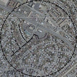
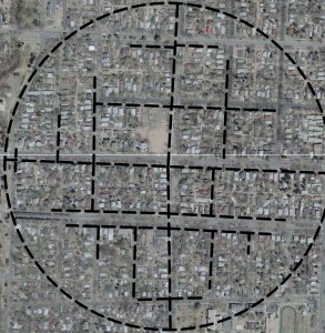
The problem with this basic diagram is that it does not take enough into account. The ¼ mile radius circle shows the distance ‘as the crow flies’ or as a linear route. Pedestrians tend to utilize sidewalks, whereas a drawing with a ¼ mile circle cannot represent this. Major arterials, fences, and walls are also commonplace in suburban locations limiting the walkability even further. I have included a couple of diagrams in Colorado Springs, one of which is for a neighborhood coffee shop in a Pre-WWII neighborhood, which I will refer to as a traditional neighborhood, and the other is in a first ring suburban area of Colorado Springs, or conventional suburban development. Notice that the traditional neighborhood diagram is set up on a well-connected grid of streets, whereas the other diagram includes the quintessential auto-centric street layout common in suburbia. The traditional neighborhood has multiple intersections, allowing more access from the pedestrian. An area with a great number of intersections per acre and short blocks will be better suited for walking than an area with few intersections and long blocks. The conventional suburban neighborhood is set up with a definitive hierarchy of streets, limiting the accessibility of potential walking consumers.
The two diagrams provided illustrate in a black dashed line actual distances of 1320-feet via the pedestrian. Notice that the outer circle in the diagrams does not come close to accounting for the actual walking conditions. As planners, we need to be careful about how we represent the five-minute walk as it can be very misleading.


2 thoughts on “The Five Minute Walk: Calibrated to the Pedestrian”
Pingback: Retrofitting at the Scale of the Block « Urban Landscapes
Pingback: The Neighborhood Unit: How Does Perry’s Concept Apply to Modern Day Planning? | Architecture, Engineering & Planning EVstudio | Denver & Evergreen Architect | Colorado & Central Texas | Blog
Comments are closed.