Although surveying with GPS can sometimes be frustrating with the lack of signal coverage, it is hands down the quickest and most efficient way to survey when it is working. When we use GPS, we tie into an established (and growing) cell network that has almost full GPS coverage on the eastern slope of Colorado. This means that we literally show up with a Leica GPS rover unit, start it up, and we are off and running (more or less). With the way we utilize the GPS rover we can easily shoot various off-site benchmarks and confirm vertical elevations in a matter of minutes. We can also obtain topography and boundary information on large sites in a short time frame.
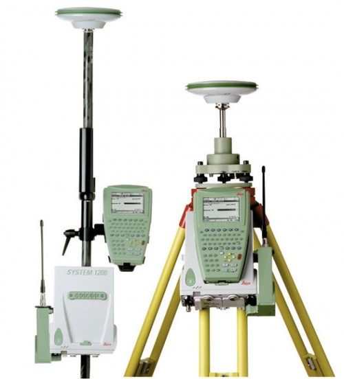
Last week, we utilized GPS to do boundary and topography mapping in Evergreen, a Land Survey Plat in central Denver, and topography mapping in south Denver all within about a 24 hour period. We also shot various off-site benchmarks, section corners, etc in addition to the on-site surveying. With a total station survey system there is simply no way we would’ve been able to complete that amount of work and still feel comfortable with the accuracy of the data we obtained.
This efficiency allows us to pass the savings onto our clients without compromising the quality of our work.







2 thoughts on “Land Surveying with GPS”
Dean — Good question– The short answer is that in “perfect” conditions GPS is easily as accurate as any traditional methods. The tolerances of GPS data depend on a lot of variables and understanding those variables is what often has an impact on how accurate the data is. For example, when we use GPS we get on a state wide network (similar to a cell phone network) that has great coverage in some areas and less coverage in others. The network is growing in coverage and currently, at least half of the state (including all of the front range) has excellent coverage. The other option is to set up a local base station which then eliminates the concern of having to rely on the existing network for coverage. Down side to using a localized base is that the set-up and break-down time is much long and requires more equipment then simply showing up on site, turning on the GPS rover and starting to shoot.
Based on our experience, the biggest issue that we’ve faced with GPS is that in certain circumstances a site with a lot of trees can cause the accuracy of the GPS to go down. On a site with limited tree cover we are often getting within a few hundredth’s horizontally and vertically. That is why (when possible) we do a reconnaissance field visit before our field surveying to assess whether GPS will be optimal or not. Thanks!
DJ,
As you know, I used to work on a survey crew in Breckenridge several years ago. I’m curious: What are the tolerances of GPS data and how does it compare to traditional methods using a total station (assuming human error is equal for both)?
Comments are closed.